The 2026 Master Plan Reexamination Report Overview claims one of the primary goals is to “Encourage public realm and private development that maintains the scale and character inherent in the diverse and historic neighborhoods of the Township”.
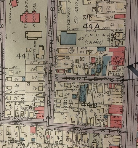
1933 Map excerpt showing Washington, Hartley and New Streets
And from the 2006 and 2016 Master Plan Reexamination:
Land Use Objectives #1
The racial, income and age mix of Montclair’s citizens is desirable, and policies should seek to preserve this range and balance.
The facts demonstrate that the racial and income mix of Montclair has been irrevocably changed by the Planner’s actions. The African American population has decreased significantly with intensified displacement of residents between 2020 and 2024. During this period the African American population declined from 9,326 to 7,503, a decrease of 1,823 and average annual decrease of 4.89%.
Land Use Objectives #2
Development does not harm quality of life of surrounding neighborhoods and new construction is similar scale and style to existing.
Land Use General Recommendations #1
Prevent new construction that is out of character with existing built environment.
Land Use Development Regulations Recommendations #1
Establish maximum impervious surface and building coverage requirements.
The displacement of Montclair’s African American residents is a direct result of the use of Spot Zoning, an illegal practice, to effectively convert the Naturally Occurring Affordable Housing (NOAH) in the 4th Ward of Montclair into luxury housing.
Spot Zoning is the illegal practice of amending zoning for a single parcel, inconsistent with the master plan, often used to bypass development rules.
Spot Zoning is generally forbidden if it serves private interests rather than the public good.
There were over 12,000 African Americans living in Montclair according to the 2000 census. A quarter of a century later there are 7,500. That is a decrease of 4,500 or 37.5%.
Between 2019 and 2024, the Board of Adjustment, (“Zoning Board”) granted 112 variances to 18 properties located on Mission, New, Washington and Wheeler Streets in the historically African American south end of Montclair. Variances were approved for reduced front yard setback; reduced backyard setback; reduced side yard setback; reduced driveway and parking setbacks; reduced number of parking spaces; increased building height and width, reduced accessory structure setbacks, reduced parking space length and width, increased lot coverage, increased impervious coverage and increased fence height.
The Zoning Board Resolutions approving variances include the following language: “based upon the foregoing findings, concluded that the applicant did prove peculiar and exceptional practical difficulties and exceptional and undue hardship with regard to the requested variances … and proved that the variances could be granted without substantial detriment to the public good and without substantially impairing the intent and purpose of the zone plan and the zoning ordinance pursuant to N.J.S.A 40:55D-70C(1).”
The deliberate and systematic use of Spot Zoning has expunged the diversity of the historic African American neighborhoods of the South End of Montclair contrary to the stated objectives and recommendations of the Master Plan.
The use of Spot Zoning also violates the Mount Laurel Doctrine. These 112 variances allowed the conversion of NOAH into market rate and luxury units resulting in substantial detriment to the public good and substantially impairing the intent and purpose of the zone plan and zoning ordinance.
The intensified development facilitated by the Zoning Board impacts the entire neighborhood bordered by Bloomfield Avenue to the north, Monroe Street to the south, Willowdale Avenue to the east and Maple Avenue to the west converting at least 141 units of NOAH to luxury and market rate rentals resulting in substantial detriment to the public good.
A sample of 133 monthly rental rates listed on Zillow for units located in the Zone between June 2024 and April 2026 include only 30 listings that are affordable per HUD FY2024 and FY2025 Adjusted Home Income Limits. Units are only affordable to low-income households based upon HUD’s highest occupancy rates: 2-persons to occupy a 1-bedroom unit; 4-persons to occupy a 2-bedroom unit; 6-persons to occupy a 3-bedroom unit.
The Mount Laurel Doctrine Decision of 1975 promised to combat exclusionary zoning patterns throughout the State of New Jersey has been perverted by the Planner, converting Montclair from a socially and economically diverse community into a socially (gentrified) homogeneous affluent community.
“The White flight that occurred (During the 1960’s White Americans left Camden and Philadelphia in search of suburbia) led to rapid population growth and high housing demand in Mount Laurel Township. The once historically rural community of Black residents was displaced as they were priced out of their own neighborhoods and left with no affordable housing options.” (RPA, March 2026, “Mapping New Jersey’ Growth Part II”)
This quote describing the effect of housing discrimination in Mount Laurel led to the Mount Laurel Decision and the Fair Housing Act of 1985, applies to Montclair in 2026 with just a few edits:
The overdevelopment pushed by the Township Planner and the State of New Jersey, including the Transit Village designation, led to rapid gentrification and high housing demand in Montclair. Black residents of the once historically African American neighborhoods of the 4th ward were displaced as they were priced out of their own neighborhoods and left with no affordable housing options.
The Township of Montclair has a history of racism and the practice of segregation. The South End of the 4th Ward of Montclair includes all 3 former red-lined districts within Montclair (“neighborhoods”). These neighborhoods were primarily populated by white people when built, as far back as 1895, but by the early 20th century, due to the practice of segregation, became primarily populated by African Americans.
By the 1930’s this area became increasingly populated by African Americans and subjected to the Federal Government policy of red lining, preventing African Americans from property ownership, and subjecting the residents to financial and educational discrimination resulting in the economic disparity that persists today.
Education is the primary tool used to oppress a class of people in order for the upper class to maintain their authority and superiority, and depriving the segregated community of their right to economic and intellectual prosperity.
African Americans that were able to buy properties in these former red lined neighborhoods of Montclair have lost their homes at alarmingly frequent rates as compared to the white owners in these neighborhoods, who are most frequently absentee landlords from nearby or adjacent communities.
A high percentage of properties within these neighborhoods have been frequently sold at sheriff sales or foreclosure, along with a much higher than usual rate of tax lien sales.
Absentee landlords churn the properties regularly, some are run down to the ground, allowed to deteriorate, all the while African Americans are living there and paying rent. Or unable to pay rent because of job loss or health crisis with no resources to cope with deteriorating financial and living conditions.
These former red lined neighborhoods, D20, D21, and D22, became NOAH, with the enactment of the Federal Fair Housing Act. In the Township of Montclair, NOAH was allowed to deteriorate over time, turning the neighborhoods into a gold mine for out-of-town developers who with the complicity of Montclair Township, Janice Talley, the Town Council, and Planning Board turned NOAH into luxury housing displacing the African Americans who occupied these neighborhoods for over 100 years.
References
- RPA March 2026 “Mapping New Jersey’ Growth Part II”
Read Part V, the next installment in the series Planning for Failure: As more buildings rise, the trade-offs of development are becoming apparent: increased traffic, decreased pedestrian safety and less diversity – Part V of Planning for Failure
 Montclair Progressive or Corrupt